Introduction
In modern surveying and mapping, precision is everything. Whether working on terrain modeling, infrastructure development, or environmental monitoring, even small errors can lead to costly mistakes. To achieve high accuracy, professionals use specially designed markers that help align laser scanning and geospatial data with real-world coordinates.
These markers are crucial in drone mapping, aerial surveys, and geospatial data collection. But what makes LiDAR positioning targets so essential for high-precision surveying? This blog explores their role, benefits, and why surveyors rely on them for accurate LiDAR-based mapping projects.
1. What Are These Markers and How Do They Work?
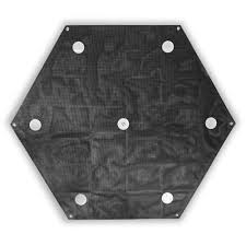
Surveying requires reference points to ensure accuracy in positioning. These targets serve as fixed geospatial references, helping to align point cloud data and reduce mapping errors.
Types of Survey Markers:
✅ Reflective targets – Designed for high-visibility laser scanning.
✅ Checkpoints – Used to validate survey accuracy after data collection.
✅ Pre-marked ground control points – Georeferenced points for aerial surveys.
2. The Importance of Accuracy in LiDAR Surveying
Laser-based mapping measures distances and generates high-resolution 3D models of the Earth’s surface. However, without proper ground markers, errors can accumulate, leading to inaccurate elevation models, misaligned datasets, and incorrect measurements.
Common Errors Without Ground Reference Points:
❌ Geolocation drift – Poor GPS calibration can misplace data.
❌ Data misalignment – Uneven terrain can cause distortions.
❌ Inconsistent accuracy – Without proper control points, data lacks reliability.
How Precision Targets Solve These Issues:
✔️ Improve geospatial accuracy by linking scanned data to real-world coordinates.
✔️ Minimize elevation errors in topographic mapping.
✔️ Ensure consistency across multiple survey missions.
3. How These Targets Improve Survey Accuracy
A. Enhanced Data Alignment
Fixed markers help anchor datasets to established geospatial coordinates, ensuring all collected data is correctly aligned. This is crucial for applications like infrastructure planning, flood mapping, and forestry analysis.
B. Improved Accuracy for UAV and Aerial Mapping
Drones equipped with laser sensors collect massive amounts of data, but positional accuracy depends on well-placed ground markers. By using pre-marked GCPs, surveyors can significantly reduce errors in aerial mapping.
C. Better Elevation Modeling in Terrain Surveys
These markers help in accurate elevation mapping, especially in projects that require precision topographic modeling for:
- Coastal erosion studies
- Mining site analysis
- Urban planning & infrastructure development
4. Applications of High-Precision Survey Markers
These targets are used in various industries that require high-accuracy spatial data, including:
A. Construction & Infrastructure Development
🏗️ Ensuring accurate site measurements for large-scale projects.
🏗️ Reducing surveying errors in road, railway, and bridge construction.
B. Forestry & Environmental Studies
🌲 Mapping vegetation density and monitoring deforestation.
🌲 Analyzing land surface changes due to erosion or climate impact.
C. Disaster Management & Flood Mapping
🌊 Tracking flood-prone areas with accurate elevation models.
🌊 Developing predictive models for landslides and earthquakes.
5. Best Practices for Using Ground Targets in LiDAR Surveying
To maximize the benefits of ground reference markers, follow these best practices:
✅ Use high-contrast targets for better visibility in scans.
✅ Distribute markers evenly across the survey area to improve accuracy.
✅ Ensure precise GPS positioning for each marker using RTK or PPK GPS systems.
✅ Calibrate sensors before each survey to avoid data distortion.
Final Thoughts
For surveyors, engineers, and geospatial professionals, precision ground markers are an indispensable tool for high-accuracy mapping and surveying. They enhance accuracy, reliability, and consistency, making them a must-have for UAV, aerial, and ground-based scanning applications.
🚀 Want to improve your mapping accuracy? Invest in high-quality ground targets today!